WASTEWATER RESEARCH AND INDUSTRY SUPPORT FORUM
Meeting 7th June 2007
Please note that for older reports some links will be to sites that are no longer active.
This was the Forum’s 33rd meeting; it was held at FWR’s offices in Marlow. The theme of the meeting was urban drainage, which in light of the floods in Northern UK that followed later in the month was topical, albeit unplanned.
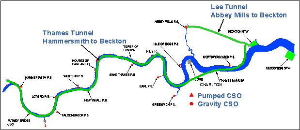
John Greenwood (Thames Water) reviewed the Thames Tideway Tunnel, which Government approved in March 2007 as the best option to deal with London’s combined sewer overflows. Sewer separation might be a preferable solution for many cities but London is a special case.
The 32.2km long, 7.2m diameter tunnel will be 40m deep in the east and 80m deep in the west, a fall of 1.2 per km. It will take the flow from the 36 CSOs that discharge to the Thames approximately 60 times per year. When it is empty, it will provide 1,600,000 m3 storage capacity and a beauty of this solution is that the storage will be available for excess flow everywhere in the catchment irrespective of where the rain falls, whereas localised storage, etc. has to deal with 100% of an extreme event in its locality. The electricity consumption is expected to be 14.7 GWh/year, which is equivalent to the combined average per capita consumption of 500 people. Since the flow velocity will not be self-cleansing, a series of penstocks are planned that will give the velocity to resuspend any sedimented solids.
The prime drivers could be said to come from Brussels, albeit the government of the UK negotiated and signed up to the legislation. There are now more species of fish in the Thames and its tributaries than since before the start of the industrial revolution. However, it still does not comply with the requirements of the Water Framework Directive (driver 1) and the European Commission has written a letter about the Thames, which could lead to action in the European Court of Justice (driver 2). Thames Water is very experienced in tunnelling. The first machine is expected to go into the ground in 2010 and the work is expected to be completed in 2020. The tideway tunnel is buildable and within a reasonable timescale. The construction cost is expected to be £2 bn but separation would have cost £12 bn.
Early in the 19th Century, sanitary drainage in cities was contained in cesspools (250,000 of them in London). These were emptied and taken, along with the prodigious amount of animal manure, to farms – cows were kept for fresh milk and horses were kept for transport. This “town manure” was very valuable until the import of dried sea-bird droppings (guano) from S. America in mid C19 and mineral fertiliser somewhat later reduced the price. The introduction of water closets was a great quality of life development but it also greatly increased the quantity going to the cesspools, which overflowed into the soil and thence contaminated nearby drinking water wells. In Paris and London policy switched from keeping surface water and sanitary waste separate to combining them in order to protect the drinking water wells. The tributary rivers were being culverted to provide building land so they were out of sight [and smell]. This was the origination of combined sewers for sanitary and surface drainage, which became the practice worldwide
.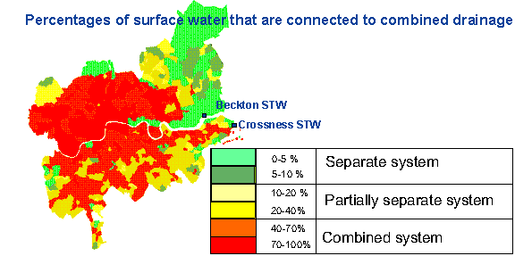
The space under London’s streets is very crowded with services so finding space for a new network would be difficult and disruptive. SUDS were found unable to make a major contribution because 55% of London is built on clay that has a permeability of only10-9 m/s whereas SUDS needs at least 10-6; much of the remainder is on water-saturated River Gravels. However, SUDS are still encouraged for all developments if it is possible. The consequence of geology and history is that 10% of the surface of the London catchment is 70-100% connected to the combined sewer network and 50% is 40-70% connected. The economics of tunnelling and the associated construction works means that even 30% reduction in the volume of the tunnel would only reduce the cost by 5%. The tunnel is the most cost effective solution for delivering the environmental obligations required for the River Thames. However, it will not prevent surface water flooding from such extreme rainfall as fell on Hull in June because some of that water would not even get into the system. Controlling surface water at source remains important, for example by modulating the release of surface water with techniques such as green roofs and permeable pavements where these can be built.
Jamie Margetts of Clear Environmental Consultants Ltd representing WaPUG (www.wapug.org.uk updated the Forum on the latest FWR WaPUG workshop on modelling runoff. Modelling is vital to managing surface water because it is the models that enable design engineers to calculate the quantity and distribution of surface water for different rainfall events and thus the sizes of drainage works to deal with them. The runoff modelling software in use today was based on field measurements made 30 years ago, albeit 100 field measurement sites were used, but it really is overdue to revisit this fieldwork.
Even at the time of the first workshop, computing power was not really adequate to go beyond 1-dimensional modelling, but now 2D is practicable. 1D restricts modelling to defined channels whereas 2D enables models to compute overflow from channels and overland flow. Workshop 2 identified that because of a lack of standardisation, models currently have limited life and limited transferability. This is a significant inefficiency. WaPUG resolved to try to increase the longevity of models and of the calibration data by introducing more standardisation and decided to share the work amongst three working groups, which met in April. A “surface standardisation” group looked at how surfaces could be categorised; this work has been made easier with the latest digital matting from Ordnance Survey which has “intelligence” about roads and buildings (http://www.ordnancesurvey.co.uk/oswebsite/products/osmastermap/) it also has a satellite imagery layer, although that is also available from Google and others. It can add further detail, for example to differentiate tarmac from gravel surfaces. Ground-truth surveying is still necessary but the workload is less than in the past.
The “surface process” group considered how to represent the connection of paved surfaces to the sewers better. Inlets are not modelled at present, for example in extreme rainfall some surface water flows over or around some designs of gullies and is passed forward. The time that a surface takes to deliver its runoff is a very significant factor and fieldwork is needed to define this better. The difficulty is modelling at the local level [individual properties]. The large area models [the Drainage Area Plans DAP] are good enough. Scandinavia and NL are much better than the UK at modelling sewer processes; in the UK we generally assume that what goes in comes out even though we know this is not true.
The third group will consider runoff parameters. Its task is to review the effect of the ‘antecedent conditions’, i.e. whether the catchment is dry, at field capacity or saturated prior to the rainfall event. I will also consider ‘impermeable surface creep’ i.e. the building of conservatories and sealing the ground with parking areas and patios. The first of the FWR-WaPUG workshops agreed that the key to developing urban drainage to cope with the extremes that are predicted to be the consequence of climate change will require institutional change and coordination across sectors that are currently separate. Whether rain falls on roofs, carparks, roads or open spaces, or if it arrives via rivers, there needs to be a planned coordinated design for managing it in the best possible way: that was back in 2002. It is very welcome that Defra has funded 16 pilot studies to examine integrated approaches.