DETERMINING THE WATER USE AND GROWTH OF FOREST PLANTATIONS THOUGH GIS-BASED INTEGRATION OF REMOTE SENSING AND FIELD DATA IN THE 3-PG MODEL
Report No: 1194/1/02
November 2002
Executive Summary
1. Introduction
It is widely recognized in South Africa that water resources are severely limited, and therefore need to be managed efficiently in order to meet the rising demand for water by the agricultural, urban and industrial sectors. One of the important factors to consider in optimising water resources is the pattern of land use in the high-rainfall, source areas of our rivers. Most of these areas were originally covered by seasonally dormant grasslands and Fynbos, but have increasingly been converted to forest plantations to meet growing demand for wood products. Over a century of experience has shown that such afforestation may result in major reductions in catchment water yields (van der Zel, 1995). The reason for this effect has much to do with the length of time that the vegetation remains physiologically active through the year. Non-riparian grasslands and Fynbos become dormant during the dry season, and hence their annual evapotranspiration (ET) is much less than that of perennial forests that are able to remain green and transpire throughout the year. Differences in annual ET between grass/Fynbos and forests may exceed 400 mm (Versfeld, 1994). Catchment Management Agencies will be tasked with managing land use and water resource allocations to ensure optimal benefits for the water management region. Decisions will need to be based on sound and credible scientific information. While much information on forest hydrology is available from past research, it remains difficult to predict spatial and temporal patterns of ET in South African plantation forests, since they are influenced by a very wide range of site factors, forest characteristics and management actions.
A recently developed "process-based" model (3-PG; Physiological Principles in Predicting Growth) shows great promise in practically predicting both growth and water use in forest stands (Landsberg and Waring, 1997). It is based on a simplified treatment of the major physiological processes governing growth and water use in stands of even-aged trees. Tree growth predictions have been validated in a number of forestry species from widely different climate and site conditions (Coops, et al., 1998; Coops, 1999a; Morris, 2000; Waring, 2000). Successful validation on several South African forestry plantations has also taken place (Gush, 1999; Dye, 2001 ). Overall, results suggests that 3-PG yields realistic results for a wide range of forest stands, and that it has great potential for providing improved, site-specific predictions of forest growth and water use. It is timely, therefore, to consider the practicality of running 3-PG spatially on an operational scale.
Several studies have been directed at investigating the potential use of remote sensing data in spatial applications of 3-PG. Coops et al., 1998, and Coops and Waring (2001 c) reported the first example of using a modified version of 3-PG tointegrate with satellite remote sensing data. A subsequent version of 3-PG (3-PG- SPATIAL) was developed to enhance the spatial use of the model through the use of GIS techniques and spatial coverages of such model inputs as topography, soils, and climatic inputs such as radiation, temperature, precipitation and humidity (Keenan et al., 2000). These studies have shown the potential benefits of integrating remote-sensing data with spatial information of climate and site conditions, through the use of GIS. The purpose of this study was to explore this potential further, and ascertain its usefulness in obtaining spatial estimates of the impacts of forest plantations on surface water resources in South Africa.
2. Project Objectives
The project objectives were defined as follows:
3. Research strategy and methods
A research strategy was designed to provide a rigorous test of the practicality of modelling diverse assemblages of forest stands with the spatial versions of 3-PG. We selected a group of 12 stands of Eucalyptus grandis X camaldulensis clones situated I in the Bushlands and Kwambonambi districts of Zululand. These stands varied in age and represented a wide range of site growth potential. Detailed measurements of biomass components, leaf area index, sap flow rates, xylem pressure potential, litterfall and weather conditions were performed over a 12-month monitoring period. Using these data, 3-PG was set up for each stand to run for the same 12-month period. Two important site variables (maximum soil water storage and soil fertility index) are acknowledged by modellers to be very difficult to quantify. Soil water storage was estimated to be consistent with the degree and timing of stress as reflected in pre-dawn xylem pressure potential readings. Site fertility index was estimated by assuming it to be correlated to site index, and to vary over a range of 0.2 to 1.0. The latter assumption was based on a similar study of Eucalyptus globulus in Australia (Landsberg, 2000).
4. Results
Realistic simulations were achieved for 11 of the 12 stands (Figure a). One stand exhibited an exceptionally high annual growth increment, and this was under-simulated by the model. The trees in this stand were shown to have access to a shallow water table, and this is believed to have resulted in physiological adaptations not recognized in 3-PG. Overall, simulated transpiration by trees in months associated with high soil water availability were realistic when compared to measured sap flow rates. In months of low soil water availability, however, simulated transpiration was too low. This is attributed to the trees using sinker roots to access deep soil water reserves below the principle rooting depth, thus avoiding severe physiological stress. We nevertheless conclude that the 3-PG model appears to be capable of describing the physiological state of trees growing in a wide range of conditions, and believe that improved predictions of growth and water use at a compartment scale are possible.
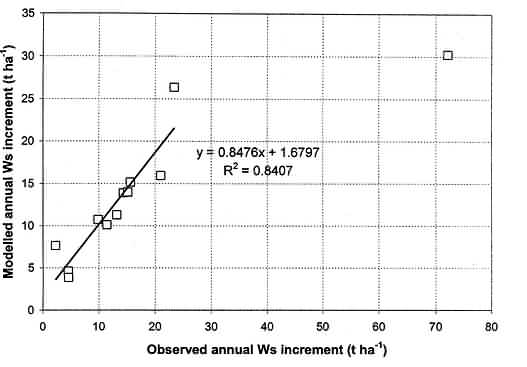
Figure a. Comparison of simulated and observed annual Ws growth increment for the 12 study sites using 3-PG. The outlier data point was excluded from the regression analysis.
5. The use of remote sensing data in spatial model applications
Assessment of the usefulness of remote sensing in spatial applications of the 3-PG model proved to be a complex task. We reviewed the recent literature on the application of remote sensing data to forest studies, as a means of highlighting the various possibilities and limitations. Major limitations that restrict the usefulness of current satellite imagery to operational forestry applications include insufficient resolution, poor image quality (especially resulting from cloud cover), high costs, inappropriate satellite pass-over times, the need for atmospheric corrections, and problems in separating tree canopy reflectances from ground and understorey reflectances. Of the various spatial inputs required by the model, only those linke(j to the quantity of green leaf in the canopies (absorbed photosynthetically-active radiation (APAR), leaf area index (LAI)) were considered feasible from affordable LANDSAT imagery, and therefore worth investigating in this project.
In a practical assessment of problems of combining remote-sensing (RS) data into spatial models using GIS techniques, we first examined correlations between four RS vegetation indices and two ground-based estimates of LAI. These were disappointingly poor, with highest correlation (r2 = 0.61) shown between NDVI and LAI based on destructive tree sampling. Since leaf area is a critical feature of tree stands that greatly affects rates of growth and water use, we accordingly chose the option of running the spatial version of 3-PG without input of remotely sensed data.
The model was set up for a sample area in the Kwambonambi and Bushlands districts. Spatial coverages of soils and long-term average climate parameters were obtained for this purpose. Simulations over an assumed eight-year rotation produced realistic final yields. The spatial patterns of these modelled yields closely followed soil patterns, indicating that the 3-PG soil parameters are important determinants of tree growth in the Zululand area. Model outputs clearly reflect the scale of the soils data. Successful simulation of tree growth at the compartment scale will require more detailed soils coverages that reflect local variations in soil characteristics.
6. Conclusions and recommendations
The following main conclusions and recommendations arose from this project:
7. Capacity building
This project was planned to make a significant contribution towards building research skills in a number of younger researchers. Mr Sibusiso Mthembu in particular was earmarked for intensive training in remote sensing and GIS modelling. This project contributed to the costs of his MSc degree in the Centre for Environment and Development, University of Natal, and he benefited considerably from interactions with Bekee Megown. With his departure, the main skills transfer effort was re-directed to Shayne Jacobs. Following a sudden loss of remote sensing skills in the CSIR, the project supported a one-week visit by Shayne to Pretoria in order to receive training within the CSIR remote-sensing group. The project also funded a one-week visit to the project team by Nicholas Coops from the CSIRO in Australia. Ms Cindy Pretorius from the Pretoria remote-sensing group was invited to the Durban office during this visit, to gain experience from Dr Coops in using remote-sensing data for spatial application of 3-PG. This project supported her costs in this regard. David Drew, and two CSIR interns (Darren Naidoo and Frank Venter) gained valuable experience in various ecophysiological techniques during the course of this project. David has drawn on this experience in planning his MSc degree in the University of Natal.