The Development of Appropriate Procedures Towards and After Closure of Underground Gold Mines from a Water Management Perspective
Report No 1215/1/05
March 2005

EXECUTIVE SUMMARY

A need was identified by the Water Research Commission to undertake research into the issue of mine closure planning from a water management perspective in the South African gold mining industry. Initially a project was conceived that was based on undertaking a more detailed study on the development of a coherent and integrated closure planning process for a case study region – the Klerksdorp-Orkney-Stilfontein-Hartebeestfontein (KOSH) area. This approach was eventually abandoned due to the unwillingness of the gold mines in this region (other than Anglogold) to participate in the project.

The project methodology was subsequently modified and approved by the project Steering Committee to rather study the complete South African gold mining industry and develop a closure planning methodology that would have application throughout the industry. In support of such an industry-wide study, an assessment would be undertaken of the current status of closure planning contained within the mine EMPRs.

Review of Mine EMPRs

An assessment was made of gold mining EMPRs on the basis of the approved EMPRs as at the end of 2001. It must be recognised that as EMPRs are regularly being updated, a number of the identified shortcomings would possibly be addressed in revised EMPRs that have been submitted since the review was undertaken. However, the conclusions that were reached are considered to be a valid reflection of the status as at the end of 2001. The review focused on those parts of sections 5 and 6 of the EMPRs that describe the decommissioning and closure phases of the mine’s operations and can be summarised as follows:

There is a definite need for clear guidance on what type of technical investigations need to be undertaken to provide the following information:
It is also clear that, to date, closure planning is not being undertaken on an integrated regional basis, resulting in those mines that have the longest remaining working life in each region being at the highest risk of being held responsible for dealing with the cumulative regional problem. This situation is clearly not equitable and it is therefore urgent that appropriate procedures be developed to ensure that effective closure planning occurs timeously and on an integrated regional basis.

Review of regional geology and identification of regional water management areas

A detailed review is presented in the report of the geology and geohydrology in the different mining areas. While issues relating to surface water management are taken into account, it was determined that the primary need for regional assessment was dictated by the geohydrological interconnections between mines as whereas surface water interconnections could easily be managed and modified, geohydrological interconnections could not.

We have identified ten major gold field regions currently mined in South Africa based on their depositional environment and geohydrological boundaries, rather than their provincial boundaries. The reasons being that in terms of long–term groundwater management systems, it is more sensible in some instances to implement this on a regional basis than an individual mine or provincial basis. This is in part due to the inter-connections that exist between the underground gold mines and the inflow of extraneous water into the underground workings.  It is also important to note that more than one mine may impact on a certain geohydrological regime and that the mine boundaries will not necessarily coincide with geohydrological boundaries.

The gold mine regions have been divided as follows:

Witwatersrand Basin
  • Free State goldfield
  • KOSH(Klerksdorp-Orkney-Stilfontein-Hartebeestfontein) area
  • Far West Rand
  • West Rand basin
  • Central Rand basin
  • East Rand basin
  • Evander goldfield
Non-
Witwatersrand
Basin
  • Pilgrims Rest goldfield
  • Barberton goldfield
  • Kwazulu Natal - Klipwal

Of the above mine groupings, the Free State and KOSH mines fall into the Middle Vaal water management area, while the Far West Rand, West, Central and East Rand Basins and the Evander mines all fall into the Upper Vaal water management area. The Kwazulu Natal mine falls into the Usutu / Mhlatuze water management area. The Barberton mines fall into the Nkomati water management area with the Pilgrims Rest mines in the Olifants water management area.

The individual gold mining regions were investigated further in terms of their geology and geohydrology to establish whether further sub-divisions were required.

Free State goldfields
It was established that the Free State goldfields should be further subdivided into 5 sub-basins as set out below.

The Theunissen sub-basin consists of Joel and Beatrix gold mines, situated between the De Bron and Stuurmanspan Faults. These mines are not interconnected through mining, but hydraulic connectivity does exist through geological structures. Beatrix gold mine has pumped in the order of 30 megalitres per day (Ml/day) from the Witwatersrand aquifer during the 1990’s. This has resulted in a dewatering cone developing in the aquifer, which has dewatered part of Joel mine as well, to the extent that groundwater inflows into Joel seldom exceeded 10 Ml/day during that time. Groundwater abstracted from the mines is evaporated on the mine property as well as piped to Welkom, where it is also evaporated.

The Oryx sub-basin consists of Oryx gold mine. This mine is isolated from the other mines and the Stuurmanspan Fault in the east and the Border Fault in the west mark its boundaries. This mine has been plagued by large groundwater inflows (~60 Ml/day). This water is also derived from the Witwatersrand aquifer and temperatures of as high as 60º Celsius are recorded. Groundwater pumped from the mine is evaporated.

The Virginia sub-basin consists of the Harmony gold mines (Harmony original, old Virginia, old Saaiplaas, old Erfdeel and old Merriespruit). These mines are all interconnected and the De Bron Fault marks its western boundary. The distal depositional environment and the disappearance of economical reef horizons form the eastern boundary of this sub-basin.

The Welkom sub-basin consists of the President Steyn (south), St. Helena, Harmony (President Brand and Unisel), Freegold (Matjhabeng, and Bambanani) and ARM gold mines. The Border Fault forms the western boundary and the Welkom goldfield is separated from the Virginia sub-basin by the De Bron Fault structure.

The Odendaalsrust sub-basin consists of the Freegold (Tshepong and Jeanette), President Steyn (north) and Target gold mines. The Border structure forms the western boundary and mining to the east is restricted by the Dagbreek fault.

For the Free State sub-basins a regional approach to dewatering may be more effective in reducing the groundwater levels to the benefit of all mines concerned. Pumping rates generally range from 2- 23 Ml/day. It does not seem likely that water will decant from any of the gold mine shafts in this region after cessation of mining and flooding of mine workings. However, the serious threat of contamination of the shallow, good quality water, the Karoo aquifer, through the residue deposition on surface or through the large-scale evaporation of saline water pumped from the deep Witwatersrand aquifer, needs to be addressed.  

KOSH area
The KOSH area is underlain by dolomite. The goldfield can be subdivided into four groundwater compartments, but due to the interconnections existing between the mines, a closure water management strategy should be integrated across all the KOSH mines. The mine workings, after flooding are likely to decant. There is also significant surface-groundwater interactions that impact on water quality in terms of pumpage of water from the mines to surface water, recirculation of water in the mines, continuous seepage from surface tailings dams and return water dams, eye flow and seepage. The high sulphide ores in this area result in potentially high long-term risk of water pollution from both the underground workings and surface residue deposits. Pollutant prevention management strategies need to be included and transport of pollutants properly evaluated. Sinkhole formation and backfilling of these sinkholes also need to be addressed in the closure planning process.

Far West Rand
In terms of gold mine closure planning, the Far West Rand mines can be divided into three geohydrological management units viz. the eastern, central and western sub-basins. These sub-basins include the Gemsbokfontein (eastern sub-basin), Venterspost, Bank and Oberholzer (central sub-basin) and Turffontein (western sub-basin) groundwater compartments. While dykes, which are considered impermeable separate the compartments, there is still interaction between different compartments due to spillage from one compartment to the next in the form of “eyes” or fountains. Furthermore, some of the upper portions of the dykes are weathered causing flow from one compartment to another.

The groundwater is found in two distinct aquifers. The gold mines in this area are mainly situated underneath the deeper dolomitic aquifers. The deeper aquifer is significant in terms of future water supply sources and is vulnerable to contamination with poor mine water upon filling. The upper perched aquifer is at risk of contamination from surface waste residues and seepage from backfilled sinkholes. This contamination is however not thought to pose a serious threat to the lower aquifer. The dewatering of the dolomitic compartment and the subsequent lowering of the groundwater levels has resulted in significant sinkhole formation and widespread ground stability problems. Decanting is likely once mining ceases in this area. Poor decant water quality will impact on surface water resources. Groundwater stability levels will be dependent on the adequate sealing of the dykes.

West Rand basin
Mining in the West Rand basin caused the creation of an artificial aquifer. A single geohydrological unit for closure planning coincides with the mining boundaries. All the gold mines are interconnected as indicated by a flat groundwater gradient within the mined out workings.  Groundwater quality is poor and the area has recently started to decant. There are also significant surface-groundwater interactions that impact on water quality in terms of continuous seepage from surface residue deposits.

Central Rand basin
The closure water management strategy for the Central Rand involves three sub-basins viz. the Central (including Rose Deep) sub-basin, the DRD and Rand Leases sub-basin and the ERPM sub-basin. These sub-basins are interconnected but are currently separated by mining pillars and the installation of plugs. Rainfall and stream flow where it crosses the reef outcrops are the predominant sources of water recharge and flooding into the aquifer and mine voids. Recharge rates of 99 Ml/day (summer) and 77 Ml/day in winter have been estimated.

The DME strategy involves closing all the ingress point. This is particularly true of the western (DRD) sub-basin. Many mines are already closed or abandoned in the Central Rand basin leaving the task of dewatering to only a few mines. Pumping from the two ends  (DRD and ERPM) of the central Basin has also been suggested to maintain water levels.

There are also potentially long term surface and ground water pollution problems from decant water and seepage from surface residue deposits.

East Rand basin
The East Rand basin also consists of interconnected underground gold mines that are separated from the Central basin by the “Boksburg gap”, which is just an unmined area. The task of dewatering is carried by only a few remaining mines, with the most significant volumes coming from the deeper mines. Two distinct dolomitic aquifers occur in this region, however, the northern aquifer plays the predominant role in terms of inflow to the gold mines. This inflow is attributed to mining induced fractures that obscure the exact inflow positions. The link is however believed to be the faults cutting across the Blesbokspruit. The area will decant once pumping ceases and groundwater will exit at Nigel.

Evander goldfield
The Evander goldfield groundwater management strategy will need to be integrated across the area since all the gold mines in Evander belong to one mining group and all the shafts are linked through underground workings. There may be three aquifers present in this area that may or may not be interconnected. They include an unconfined Karoo perched aquifer close to the surface; a confined or semi- confined aquifer within the underlying dolomite and the possibility of a confined Witwatersrand connate aquifer. The latter is usually characterised by saline water. A critical issue here is the presence of the Ventersdorp lava within this basin, which would form a barrier between the overlying aquifers and the mined out barrier.

Non-Witwatersrand basin
This section covers the Pilgrims Rest, Barberton and Kwazulu Natal (Klipwal) mining areas. Information has not been readily available and is limited for these last three areas. Moreover, a review of their geohydrological profiles indicates that these gold fields could each be managed as individual regional units with respect to closure planning. Pilgrims Rest and Kwazulu Natal have only one operational mine in each region. Barberton has eight gold producing regions and over 130 mines. However, these Barberton mines are generally small, single adit operations that could also be managed as a combined unit. Moreover, due to budget constraints and time already spent in attempting to fill in the data gaps for these regions, it was decided that this aspect would not be further pursued. However, it is recommended that a separate study be conducted to better understand the interconnections and groundwater interactions of the Barberton mines.

A summary of the key elements raised in this situation assessment is presented in Table E1 below.

Table E1: Geohydrological assessment data summary for closure planning of underground gold mines

Goldfield  Free State  KOSH Far West Rand West Rand Central Rand East Rand  Evander Pilgrims Rest  Barberton  KZN
Water Management Area  MiddleVaal MiddleVaal Upper Vaal UpperVaal   Upper Vaal  Upper Vaal  Upper Vaal   Olifants  Inkomati  Usutu to Mhlathuze
Geo-hydrological groundwater management units  5  1 3 1 3 1 1 1 1 1
Decanting  Not likely  Yes  Likely  Yes Yes Yes No Likely Some Unlikely
Decant rate  0 17-50 Ml/day  ?  Estimated at 17 Ml/d 17 Ml/d  ? - - - -
Physical instability(Subsidence/ sinkholes)  No  Yes Yes Yes Yes Yes  No  No No  No
Pumping of flooded mines  Yes  Yes Yes Being flooded  Yes Yes  No No Some Yes
Pumping rates  34 Ml/d  Stilfontein  >150 Ml/d  -   99 Ml/d (summer)  90 Ml/d  - - - -
Strong surface-groundwater interactions Hydrochemical pollution sources (such as waste dumps, evaporation dams and slimes dams)
Saline water pumped from deep connate aquifer and surface evaporated (Free State mines)
Recharge water  degradation  of dolomites
Transport routes such as surface run-off, primary aquifers, dolomitic aquifers, fractured rock aquifers and geological features such as faults and dykes
Chemical stability (water quality e.g. AMD problems A positive correlation exists between gold grade and the modal proportion of potentially acid producing sulphide minerals. Furthermore, gold grade correlates positively with the reef thickness. Thus by making use of isopach maps showing the distribution of reef thickness, meaningful planning and delineation of areas with a high acid producing potential is possible.

? = missing data

Proposed regional mine closure strategy

The principles of risk-based mine closure planning were adopted and a procedure was developed and presented to enable risk-based regional mine closure planning to be implemented. A detailed risk-based closure planning process is presented, together with flow charts aimed at the development of a regional closure planning process. In assessing the closure issues relating to water, the following important points need to be considered:
  1. The source of water-related impacts on a gold mine can be divided into two primary components, i.e. aboveground features and underground features.
  2. All South African gold mines are extracting ore and waste material that are associated with sulphide minerals (and a greater or lesser amount of neutralizing minerals) and other contaminants and there is, therefore, an inherent water quality risk associated with gold mines.
  3. The gold mines are generally grouped together very tightly, resulting in hydrological interconnections between adjacent mines. This makes it difficult, if not impossible, to consider the water-related closure risks in isolation and consequently, a number of distinct hydrological groupings of mines has been defined, each of which should develop a regional mine closure strategy within which individual mine closure plans can be assessed.
  4. The surface residue deposits (tailings dams and waste rock dumps) that remain after mine closure can never be maintained in a completely reducing environment and must be considered to pose a potential water related risk until shown otherwise by way of a suitable semi-quantitative or fully quantitative geochemical assessment.
  5. Underground mine workings will fill up with water over time (slow or fast depending on geohydrological setting) and this water will be contaminated (either for a limited time or in perpetuity). A key element influencing the risk that these processes pose to the water resource is whether or not this contaminated water will decant into the underground aquifers or into the surface water resource and to what extent the natural water resource can assimilate this contamination. The underground workings must, therefore, be considered to pose a potential water related risk until shown otherwise by way of a suitable semi-quantitative or fully quantitative geohydrological and geochemical assessment.
  6. In certain mining regions, underground dewatering activities and placement of surface residue deposits pose a long-term risk with regard to formation of sinkholes that in turn pose safety, water resource and land use risks that need to be assessed.
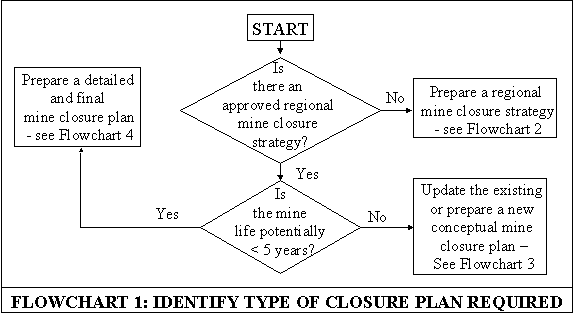
With the above in mind, a set of procedures have been developed to address the various elements of regional mine closure strategies and individual mine closure plans. The first step in the process is to define the nature of the closure plan that is required and this question is simply addressed in Figure E1 below.


Closure plan flowchart
Figure E1: Flowchart to identify type of closure plan required

Based on the flowchart process shown in Figure 6.4, three possible outcomes exist:
The above process incorporates the principle that a conceptual mine closure plan can be developed in the absence of a regional mine closure strategy but that no final mine closure plan can be developed until an approved regional mine closure strategy is in place.

Preparation of a regional mine closure strategy
Due to the fact that most mines are hydrologically interconnected with the adjacent mines, the closure of one mine within a region will often have impacts on the remaining mines. There is also a risk that the cumulative impact from all the mines in a region could be imposed upon the last mine in the region to cease operations. This poses a secondary risk that this last mine could be held responsible and liable for the cumulative impact of all the mines or, as a minimum, that it would be difficult, if not impossible, to apportion liability to the contributing mines within a region. It must also be recognised that different mines within a region will cease operations at different times and some framework must be established within which these mines can plan for mine closure. It is, therefore, recommended that a number of regional mine closure strategies be developed for the different regions that have been identified.

In the development of a regional mine closure strategy the first step is to establish which mines are included within each region. While it is not the responsibility of the research team to dictate who funds the development of a regional mine closure strategy, it would clearly be reasonable that either all the mines within a given region jointly manage and fund the development of this strategy, or that the State take responsibility.

Based on the research undertaken as part of this project, 17 different regions have been identified as shown in Table E2 below. The grouping is essentially based on connections between the underground workings and the geohydrological units that apply. In all cases other than the Far West Rand Central sub-basin and Eastern sub-basin, mines grouped within a geohydrological region are also located within the same surface hydrological unit. Regional mine closure strategies developed for these 2 sub-basins will need to take cognisance of catchment management plans developed for the adjacent catchments.

Update the existing or prepare a new conceptual mine closure plan
Whereas the focus of a regional mine closure strategy is to understand interactions between adjacent mines and to find a basis for agreement on how much contamination (waste load allocation) is permitted for each mine, the focus of an individual mine closure plan is on how to manage the mine closure process to most optimally comply with the agreed waste load allocation. This process requires the mine to integrate the impacts that derive from its underground mining operations and those that derive from the surface waste residue deposits.

It is proposed that a new or updated conceptual mine closure plan can be developed at the same level of detail and using the same assessments that were undertaken for the regional mine closure strategy. This means that the mine will probably be able to meet the requirements for understanding and managing the impacts from the underground operations by using the geohydrological and geochemical studies undertaken for the regional mine closure strategy. With regard to the surface impacts, the mine will need to undertake a screening level assessment of the impacts associated therewith. For both the underground and surface impacts, the closure plan will then focus on evaluating various broad management strategies that are capable of reducing the total mine impact to an acceptable level as dictated by the approved waste load allocation. The conceptual mine closure plan should be reviewed and updated on the same frequency with which the mine undertakes its EMP performance assessments.

Table E2: Regions for regional mine closure strategies
Area  Geohydrological Unit Mine Quarternary Catchment   Tertiary Catchment Name
KOSH KOSH
KOSH
Stilfontein, Hartebeestfontein & Buffelsfontein 
Vaal River Operations & ARM
C24A
C24H
Schoonspruit
Schoonspruit
Free State Odendaalsrus sub basin
Target, Jeanette, Tshepong & PS North
PS South, St Helena, P Brand, Unisel,
C25 Makwassie spruit
Welkom sub basin
Matjhabeng, Banbanani & ARM 
Harmony original, Old Virginia, Old 
C43B
Vet
Virginia sub basin Saaiplaas, Old Erfdeel, Old Merriespruit C42J Vet
Oryx Oryx C42L Vet
Theunissen sub basin Joel & Beatrix C42K Vet
Far West Rand Western sub basin  Deelkraal, Driefontein, Blyvooruitzicht, Western Deep & Elandsrand  C23E  Mooi
Central sub basin  Kloof   C22J Klip
Venterspost, Libanon  C23D Mooi
 Eastern sub basin  Placer Dome C22H Klip
 Harmony Cooke C23D Mooi
Barberton Barberton New Consort  X23B Krokodil
Barberton  Sheba X23G Krokodil
Barberton Fairview, Agnes X23F Krokodil
Evander Evander Winkelhaak, Bracken, Leslie & Kinross C12D Waterval
West Rand  West Rand Randfontein Operations & West Wits A21D Upper-Krokodil
Central Rand  DRD and Rand Leases DRD, 5A shaft & Rand Leases C22A Klip
Central CMR, Crown, Rose Deep & City Deep C22A&B Klip
ERPM ERPM C22B Klip
East Rand  East Rand Grootvlei & Modderfontein C21D Suikerbosrand
Nigel C21E Suikerbosrand
Pilgrim’s Rest Pilgrim’s Rest Transvaal Gold Mining Estate B60A Blyde

Prepare a detailed and final mine closure plan
When it is anticipated that the mine’s remaining operational life is in the order of 5 years, the mine will need to undertake a substantial review and overhaul of its conceptual mine closure plan and will need to significantly upgrade the level of certainty associated with the various assessments. While the process is essentially similar to that employed for the development of a conceptual mine closure plan, the level of detail and the depth of the assessment will vary. In particular, it is proposed that detailed mine closure plans should be probabilistic in nature, i.e. they should aim to define the uncertainty associated with the assessment.

The DWAF is in the process of developing Best Practice Guidelines for the prediction of pollution from mining sites and the methodologies set out in these guidelines should be used in undertaking the assessments required to develop mine closure strategies and mine closure plans.

Recommendations

The primary recommendation of the research project is that the basis of mine closure planning in South Africa should be modified. Whereas, mine EMPRs, mine authorisations and mine closure plans are drawn up, evaluated and approved on an individual mine basis, there is a need for this process to be modified to take account of regional issues. The following process has therefore been recommended:

  1. Regional mine closure strategies should be drawn up for the 17 gold mining regions defined in the report. These strategies should establish the ground water and surface water interconnections between mines within a region and should be integrated with the catchment management plan drawn up for the relevant region. The regional mine closure strategy will need to be undertaken as a cooperative venture between all the mines and should result in a broad regional strategy that includes the equitable apportionment of waste load between mines. Details on the strategy development and content are provided in Chapter 6.
  2. Individual mines will then be required to develop their individual mine closure plans, to be submitted to the DME as part of the mine’s EMPR. These individual closure plans will need to be developed within the context of the approved regional mine closure strategy and could either be in the form of a conceptual mine closure plan if the mine has more than 5 years life remaining, or in the form of a detailed and final mine closure plan if the mine has 5 years or less of planned operational life remaining.
  3. Interim procedures and policies need to be negotiated to enable the transition from the current status to the proposed new procedure. In this regard, it is proposed that an implementation period of say 5-10 years be agreed, within which a regional mine closure strategy must be developed and approved and mine closure plans be converted to conform top the approved closure strategy.
  4. It is also recommended that no mine be permitted to switch off dewatering pumps or commence with flooding of portions of the mine without having an approved detailed and final mine closure plan that fits within an approved regional mine closure strategy. This is to ensure that any management actions that need to be implemented before a mine floods are timeously identified and implemented to reduce the risk of long-term water pollution problems.
  5. It has been recommended that the regional mine closure strategy also address the issue of waste load allocation between mines on an equitable basis. Liability for long-term water management actions should then be apportioned on the same basis as the waste loads.
  6. A recommendation has been made to the Department of Minerals and Energy that the proposed mine closure strategy be incorporated into the new Minerals And Petroleum Resources Development Act, 2002 (Act No 28 of 2002).
  7. It is recommended that a separate study be conducted to better understand the interconnections and groundwater interactions of the Barberton mines.