Analysis of Groundwater Level
Time Series and the Relation to Rainfall and Recharge
Report No. 1323/1/05
March 2005
EXECUTIVE SUMMARY
Introduction
Groundwater levels in South Africa have been recorded routinely and on
a national scale by the Department of Water Affairs and Forestry since
the mid 1950s. Since that time this task has been expanded
significantly and currently a few hundred boreholes are monitored on a
regular basis. Knowledge of long-term rainfall variability
and the associated response of the country’s groundwater
resources are essential for efficient and sustainable groundwater
resource and land management. Despite the relatively short
period for which water level records are available, these records
contain valuable information that can be used beneficially in the
development of technologies to assist in the responsible management of
our limited groundwater resources.
With this in mind, some South African groundwater level time series
information was selected and studied using a new and novel approach
based on a recently developed technique to monitor drought
conditions. The results are presented in this report.
Aims and objectives
The main aims of the project were three fold:
- To collate long-term groundwater level information and
investigate new methods that can be used to correlate these long term
groundwater level fluctuations with rainfall and climatic cycles;
- To determine whether the apparent long-term declining
trends observed in South African groundwater level data is indicative
of a current and/or longer term groundwater drought cycle(s) or whether
other factors are contributing to this trend; and
- To document the analytical techniques available and used to
analyse relevant geohydrological information to assist planners in the
longer term planning of groundwater utilization as part of the
envisaged national Integrated Water Resource Management plans.
A methodology to simultaneously analyse groundwater level and rainfall
information of southern Africa and correlate this information to
drought and other long-term climatic indicators or cycles is proposed
in this report. It is envisaged that the further development
of the concepts expressed in this report, may eventually lead to the
development of indicators that can be used to improve the current
groundwater recharge estimations and thereby the long-term management
of the important national groundwater resources.
In view of the international research emphasis on climatic change, it
was believed to be important to assess the status of knowledge on
climatic variability in southern Africa over recent geological times
and specifically the last few thousands years. This review
highlighted the large variations in climatic conditions that have
occurred over time and allows one to consider the climatic changes that
have taken place over the last 50 to 100 years, and the changes that
are predicted for the next centuries, in perspective.
Brief description of some
results
Based on the documented record and numerous studies on the
palaeo-climatic conditions in southern Africa, climatic cycles of
different length and intensity appear to have been present during the
last approximately 200 000 years and more specifically the last few
centuries. These can be summarised as:
- an approximately 23 000 year cycle of major wet and dry
periods during the last approximate 200 000 years;
- a possible 400 – 500 year
“cold/warm” or “wet/dry” cycle;
- an ~120 year cycle;
- an ~18 year cycle; and
- an ~11 year cycle.
In the documented South African groundwater level information, a number
of different water level fluctuation cycles or trends are
present. These are classified as
- Short term (~1 year) fluctuations in the groundwater level
data;
- Medium term (~10 years+) cycle in the groundwater level
data; and
- Longer term trend which may be of a cyclic nature, but due
to the short time series, it is not clear whether it may perhaps be
part of a longer cyclic period.
Of particular interest are the declining trends, often extending for 10
or more years that are observed in some of the data sets. These do not
appear to be associated with a particular geohydrological, geological
or climatological region, but are present throughout the country.
Another important observation is the rapid response of groundwater
levels to periods of excessive rainfall, often by several metres over a
period of a few months.
Closely linked to periodicity in water levels, is the concept of
“groundwater drought”, which may have important
management implications, but has not yet received sufficient
attention. Researcher from the United States used the Palmer
Drought Index (PDI) and the more recent Standardized Precipitation
Index (SPI) to formulate a “Drought Index” that
provides information on drought duration, frequency and time
scales. Selected groundwater level and monthly rainfall time
series from South Africa were analysed by correlating the groundwater
level records with the Standarised Precipitation Index (SPI) values
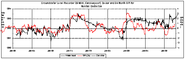
derived for South African rainfall data. An example illustrating the
correlation between a water level record of more than 40 years from a
borehole near De Aar and the associated SPI is given below Figure 1.
The correlation between the two datasets is remarkable over the entire
record period and both the larger and smaller anomalies (amplitude and
duration) correlate well, especially for the first section of the
record. Where groundwater levels follow even the small variations in
SPI values, indicates that in selected cases, at least some groundwater
recharge occurs during almost every year.
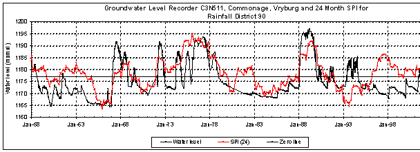
In the second example sudden groundwater level changes of around 25m
(rapid recharge) correlate well with periods of high SPI values
(consistently wet years), while extended periods of declining water
level again correlate with extended periods of low SPI values
(consistently dry years). However, not all examples analysed during
this research project showed similar high correlations. The
reasons for this are not apparent.
Figure 1: Groundwater level response at recording station
D6N500 (borehole 3024CA00328) on the farm Caroluspoort, De Aar district
with the associated SPI using the rainfall record of Rainfall District
54.
Figure 2: Groundwater level response at recording station
C3N511 (borehole 2624DC00032) on the farm Commonage, Vryburg district
with the associated SPI using the rainfall record of Rainfall District
90.
No evidence was found that a consistent and constantly declining trend
in South African groundwater level information is present, at least
over the approximately 50 years for which information is available.
There are, however, in many of the long-term records periods of
extended declining groundwater level. These were found to
continue in some instances for up to 20 years. These long
declining trends are also often terminated by sometimes abrupt rises or
return of the groundwater level to the original reference level, or
sometimes even higher. Depending on the intensity and
duration of the rainfall event or the period over which above average
rainfall is recorded, this return of the groundwater level occurs
within months after the onset of the rainfall event. This can be
explained by a combination of factors, such as the intensity and
duration of the rainfall period, the geohydrological conditions in the
vicinity of the recharge area for a particular aquifer of the
monitoring borehole, the physical parameters of the unsaturated zone,
and others. Further, no indication could be found that the current
cycle of climatic change experienced throughout the world and that is
predicted to intensify during the next decades, is reflected in any way
in the South African groundwater level records. It must also
be stressed that the predicted changes in climate for the southern part
of Africa, are relatively minor compared to those that are documented
in the geological record of the last few million years.
It is proposed that the observed correlations between SPI and
groundwater level fluctuations can be used to calculate a generic
“recharge index” for a region. Based on
the way the SPI values were calculated and reported in this project,
the “recharge index” could be representative of a
rainfall district, and not necessarily a region of similar
geohydrological conditions. When developed further, this
approach may result in improved quantification of groundwater recharge
on a regional basis in Southern Africa.
From an analysis of the SPI and long-term groundwater level graphs and
its possible use in recharge calculations, the following observations
were made:
- the SPI value has to be at least positive in order to cause
recharge. In the context of this report, recharge is
considered to occur when water levels are increasing. In many cases it
would appear that the SPI value has to be in excess of +2 to have a
meaningful impact on groundwater recharge.
- During a period of positive SPI values, water levels have
to show an increasing trend for a period generally at least equivalent
in duration to that of the SPI anomaly, otherwise limited or no
recharge will take place.
- During periods where SPI values are close to zero or
negative, no recharge takes place.
- For recharge to occur, the annual rainfall needs to be
above the long term MAP.
A methodology has been proposed to calculate the “Recharge
Index”. A number of factors are calculated with
each being given a weight. The total weight is then a
relative indication of the rate of recharge. The method proposed is
still very subjective and a great deal of additional work needs to be
done to develop this into a reliable way to turn the
“Recharge Index” into a realistic representation of
effective recharge. The example in Figure 1 above was used to calculate
the proposed recharge index for that specific rainfall
district. Based on the outcome of the calculations it is
suggested that the period between 1973 and 1978 was one of high
groundwater recharge, that of 1978 to 1986 one of no or very low
recharge, while the period between 1986 and 1992 was again one of high
recharge. No attempt was made to express the
“recharge index” value into a percentage of MAP or
any other more quantitative way of expressing recharge.
Conclusions and
recommendations
Some of the main conclusions and recommendations emerging from this
research project can be summarised as follows:
- A number of different climatic cycles (cold/warm or wet/dry
cycles) of different duration and intensity have been present or are
postulated to have been present during the last 200 000
years. These range between a cycle of approximately 23 000
years, to one of approximately 11 years cycle of major wet and dry
periods during the last approximate 200 000 years. For the
purpose of this study, the 18 and 11 year cycles are perhaps those of
most significance in assisting the groundwater resource planners.
- Although the present investigation has not investigated
this issue in any great detail, it is concluded that when viewed from a
geological perspective, the short documented record of the climatic
conditions, including the groundwater level records, no conclusive
statement can be made regarding changing geohydrological conditions as
a result of changing hydrological
or climatic conditions over say the last 50-100 years. The South
African groundwater level records cover a too short time period to make
any conclusive statements whether a steady decline in our groundwater
levels is present or not.
- The Standardized
Precipitation Index (SPI) is a relatively new development in drought
prediction technology. It has been proven in the United
States and elsewhere in the world to be a reliable tool for this
purpose. The application of this technique in the study of
the impact of drought on groundwater resources as was done in this
project, is as far as could be ascertained from the literature,
unique. As such there are no well-proven methodologies
developed yet according to which geohydrological information should be
handled to obtain the most benefit from such a correlation between the
two datasets.
- This limited study has shown
that correlations between SPI values and water level fluctuations are
present in South African data sets. The quality or degree of
correlation however, varies. Examples are presented where
excellent correlations exist, but on the other hand, some examples of
poor correlations have also been recorded. The reasons for
the presence of correlations, whether these are good or poor, are not
well understood and warrant further investigation. It was
shown that only water level data that are not impacted upon by external
forces should be used when correlating SPI values and water level
fluctuations.
- It is generally accepted
that there is a relation between water level fluctuations and recharge.
The numerous techniques developed in the past in this field are a proof
of this. The results obtained during this project, have confirmed that
the SPI methodology can also make a valuable contribution to this still
challenging field of aquifer recharge estimation.
- A first attempt in
developing a “Recharge Index” derived from SPI data
is presented in this report. Although the concepts that have
been formulated and included in the methodology may seem to be
simplistic, it is believed that the development of such an index has
merit and should be investigated further. The method on its own may not
yet provide the required quantitative assessment of groundwater
recharge, but together with other available methods to calculate
recharge, may add the required information to provide more quantitative
answers in future.
Some recommendations emerging from this research include:
- A more in
depth analysis of
the nature of groundwater level time series should be done to be able
to explain the wide variety of response patterns to climatic conditions
observed in the available South African groundwater level records.
- The
fundamental theory
behind the SPI analysis should be investigated and its possible
application to geohydrological datasets should be given a theoretical
basis.
- The
development of the
“Recharge Index” should be expanded and placed on a
sound theoretical base.
- Once a sound
calculation
methodology for the Recharge Index has been developed, it should be
calibrated in order to produce meaningful figures representing the
actual recharge that contributes to our groundwater resources.
- The process
of calculating a
Recharge Index should be automated and the derived values should be
given a reliability rating.
- Once a
reliable methodology
has been developed to calculate recharge, a groundwater recharge map of
the country should be compiled based on for example the rainfall
districts as defined by the Weather Bureau.
It is further recommended that the Department of Water Affairs and
Forestry should consider the establishment of rainfall recording
equipment close to the water level monitoring recorders. This
would enhance the reliability of the correlation between rainfall and
water level fluctuations. It is further also recommended that
the Department reconsider any recommendations made to close down any of
the existing monitoring programmes. Groundwater level records
contain important information on the long-term behaviour of aquifers
that have not been studied in any great detail, but could provide
valuable information in future that will be beneficial to the managers
of the national water resources.