HYDROLOGICAL SYSTEMS MODELLING RESEARCH PROGRAMME: HYDROLOGICAL PROCESSES RESEARCH
Phase 1 Process Definition and Database
637/1/01
October 2001
EXECUTIVE SUMMARY
Environmental modelling advances which have accompanied the developments in computer technology are a mixed blessing. Whereas, in the past, we often had a plethora of environmental data without a holistic theory, nowadays we often suffer from a growing stockpile of models, many of which have not been adequately verified. Model development has become an increasingly attractive pursuit since funding is often limited, the cost of field studies is high, time and patience limited and cooperative research is often difficult and tedious. Nevertheless, modelling and process experimentation must be an ongoing endeavour that reciprocally enhance one another with sound, comprehensive experiments and observations serving as the building blocks of models. At the same time models must serve to economise experimental designs, direct objectives and test observed phenomena. The responsibility lies in the hands of environmental researchers to adhere to the modelling process and to seek out experimentalists that can assist in building and evaluating models. Even though this warning is nothing new, the effort by modeller to heed it is still as much the exception as the rule1. The 'Hydrological Systems Modelling Research Programme' of the School of Bioresources Engineering and Environmental Hydrology, University of Natal has recognised this need and has incorporated a vigorous effort in Hydrological Processes Research.
Observations, monitoring and experimentation of hydrological processes is especially important where perturbations to the hydrological response occur due to changes in land use or climate. Here, models alone may often fall short in predicting the changes in hydrological response, unless they are built upon the sound understanding of the hydrological processes. This understanding is imperative when catchment management issues are to be resolved, where managers must know a priori, the consequences to the water resource, of such practices as community settlement of grassland areas, afforestation, invader species removal, waste disposal or extensive agricultural development, whether small community based or large schemes. Conversely, the clear understanding of hydrological processes is used to assist land users in best practice options.
During this first phase of the hydrological process research, certain key projects have been addressed. A valuable set of data has been assembled and analysed. The data and analyses have been used to interpret flow generation and storage mechanisms and computer models have been used to assess the capability of these models to simulate the mechanisms. The hydrological processes are described together with pertinent conclusions and recommendations in the following sections.
Monitored Catchments and Processes
Historic and current monitoring endeavours at catchment, hillslope and local scale are summarised and a data base, designed to allow full participation and accessibility to interested researchers or practitioners, is described. The monitored catchments include the Ntabamhlope and Cedara research catchments where some records extend back to 1964. The monitoring strategies in these catchments has been radically revised and, although still plagued by vandalism, extremely valuable data are imminent where settlement of previously grassland areas is underway.
There are currently 7 catchment scale monitored areas, many of which have multiple subcatchments and 4 areas of local, field or hillslope scale monitored experiments. Selected data sets of the Weatherley research catchment and the historic Ntabamhlope catchment have been installed in the interactive data base.
Of particular importance in these data sets is that many now contain not only the traditional rainfall and runoff data, but also data reflecting the dynamics of the subsurface water. These data sets lend themselves to the description of dominant flow mechanisms, storage and uptake.
A data base, designed to interact with the USGS Generation and Analysis of Model Simulation Scenarios (GenScn) which requires the Watershed Data Management (WDM) format, will allow for access to these valuable data by practitioners, researchers and managers. The data base is continuously populated with all available and current data from the 7 catchment areas and 4 experimental areas. In order to pre-empt the development of superior data base management tools, the primary data files are stored in ASCII format.
Hillslope Hydrological Processes
The study of hillslope hydrological processes forms the backbone of the hydrological process research programme. Mechanisms of rapid and slow responses at the hillslope scale affect the magnitude of storm flow peaks at the small (< 10 km2) catchment scale and contribute to runoff hydrographs at the large (10- 100 km2) catchment scale. Mechanisms of water storage during wet periods and subsequent release from hillslopes during dry periods, affect the sustainability of small catchment practices and can have a significant control on low-flow rates at the large catchment scale. Mechanisms of lateral flow, accumulation and redistribution on the hillslope will influence the nature and location of land use practices. Conversely, changes in land use practices may affect all these hillslope flow path mechanisms and therefore the perturbations in flow generation mechanisms are also important to define.
Of particular interest in this study are the hillslope flow path mechanisms in a research catchment in the Umzimvubu basin of the northern Eastern Cape province on the eastern coastal escarpment of South Africa. This area is sensitive to anthropogenic influences, where commercial agriculture, irrigation, domestic and rural settlements and forestry compete for water use. An adequate supply of water to this region is seen as imperative in the light of the recent establishment of forest cultivation. In order to provide a sound assessment of the impacts of the afforestation, the hydrological processes in typical Molteno sedimentary formations must be clearly understood. For this reason a detailed hillslope and nested sub-catchment experiment has been initiated in a 1.5 km2 research catchment, representative of the soils, geology, topography and climate of the region.
The research catchment, named Weatherley, was established in 1995 and has been developed into a prime research location involving many institutions. The hydrological experiment was designed for the observation of hillslope processes prior to and following afforestation The Weatherley catchment is described and selected data are presented. A number of rainfall/runoff and subsurface flow events are analysed in order to identify and define the dominant hillslope processes. Two modelling exercises, performed at different scales, are presented to substantiate the flow processes defined in the analysis of the event data. Finally, the implications of these observations on the simulation of rainfall-runoff processes in large catchments are discussed and algorithms for improved simulation by the ACRU hydrological model are proposed.
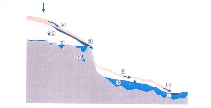
The dominant processes on the hillslopes, identified by the analysis of monitored data, are shown graphically in Figure 1 and a summary of each mechanism and its occurrence is presented in Table 1.
Figure 1 Conceptual model of flow mechanisms in the Weatherley research catchment.
Table 1 Summary of flow mechanisms and their occurrence.
| CODE | DESCRIPTION | OCCURENCE |
| A | Rapid lateral flow near the surface due to macro-pore conductance. Local perched water table of short duration. Matric pressure head discontinuity with deeper perched water table, D. | In upper slope segments in downstream catchment during high intensity events and some low intensity events with large volumes (>30 mm). |
| B | Accumulation at the toe of the slope segment with emergence and flow over bedrock. | In upper slope segments in downstream catchment. |
| C | Slow percolation to water tables perched on bedrock. | In all slope segments for most events except low intensity and volume. |
| D | Water tables perched on bedrock and in bedrock hollows. | All slope segments. Disconnected from soil water in upper slopes of downstream catchment, but connected in lower slopes and in upstream catchment during moderate to intense events. |
| E | Seepage of old water through fractured bedrock. | Assumed to occur in all slope segments. |
| F | Rapid lateral flow in flatter marsh slopes and infiltration to marsh ground water. | Vertical recharge is more rapid than lateral movement in lower slopes of downstream catchment and in upstream catchment. |
| G | Marsh ground water level fluctuation | Rapid for most events in lower downstream catchment. Slower, but connected in upper catchment. |
| H | Exfiltration and macro-pore discharge to stream. | In downstream catchment. Not observed in upstream catchment. |
| I | Marsh ground water discharge into stream. | Assumed to occur in upstream and downstream catchments. |
It was found by modelling the profiles with available soil physics or hillslope models that these models clearly lack the mechanisms of flow generation in perched, near surface water tables as well as the contribution from these macropore layers into the deeper perched water tables.
Futher research is recommended in order to quantify the rates and timing of the various flow generation mechanisms by sampling natural isotopes or natural ion tracers from the various sources, It is also recommended that the simple algorithm for lateral flow generation for catchment scale models is further developed and tested. The implications of the timing of the flow generating mechanisms and the storage and release of water observed in the hillslopes also requires investigation for low flow sequences at larger scales.
Small Scale Irrigation Processes
In the framework of hydrological processes research, irrigation practices have been studied in KwaZulu- Natal where small scale community market gardens are rapidly developing and have the potential of becoming a major water user. The study includes two locations. The first, at Willowfontein near Pietermaritzburg involves irrigation by furrow and the second, at Taylors Halt, involves irrigation by hand using containers. The dynamics of the subsurface flow is monitored and modelled in detail to assess and advise upon application efficiency. The work presented in this study addresses the need for an evaluation of small scale irrigation practices, processes and efficiencies.
The study included both a social and technical system appraisal. Evaluation of soil moisture sensing equipment was used to define the soil water dynamics during rainfall and irrigation events. Computer simulation of the observed results proved successful and further scenarios of more efficient strategies could be simulated. In the instance of the Willowfontein study, it was found that the furrow irrigation events were too infrequent and were applied for too long, causing excessive drainage below the root zone. The simulation of a scenario in which the water was applied more frequently and in smaller quantities revealed a saving of drainage of 115 mm in the month simulated. In the Taylors Halt study a less frequent application was also found to save some 80 mm for the month simulated. Figure 2 shows the cumulated water draining below the root zone for the current and proposed irrigation scenarios.
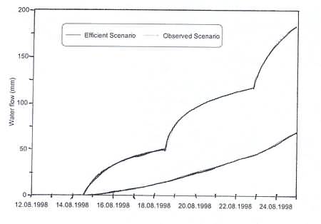
Figure 2. Comparison of observed and efficient irrigation scenarios for the Willofontein, nest 2 for August 1998.
The study highlights the use of monitoring equipment and computer simulation to assess the many nuances of small scale irrigation. The value of the study is also enhanced by the simultaneous investigation of social as well as technical aspects. It is recommended that the techniques and lessons learned in this study be communicated to the small scale farming community.
Other Hydrological Processes
The outcome of studies of contributing area sediment yield processes, irrigated mined land processes, snowmelt processes and baseflow recession curve analysis have been summarized in this project.
Contributing area sediment yield processes research is directly linked to the hillslope flow generation research and is continuing in Water Research Commission projects on hillslope hydrology and on agricultural catchments sediment yield.
Soil water processes have been studied in irrigated rehabilitated mined land. Lateral flow and accumulation of water on spoil layers has been identified and modelled. The implications for seepage through the spoil material have been assessed. This research is continuing in a collaborative study supported by the coal mining industry and the Water Research Commission.
Snowmelt routines have been included in the ACRU model and tested in German catchments.
Recession curve analyses have been completed in order to develop a rule based definition of base flow contributions to stream flow. It was concluded that until further analyses are forthcoming, the development of a rule based model for baseflow recession analysis in South Africa would be premature. The establishment of a readily accessible database containing streamflows and associated catchment characteristics, however, lends itself to future research in this regard.
Final Conclusion
Hydrological processes research is an on-going endeavour to improve the description of dominant water generation, uptake and storage mechanisms, particularly where land use changes influence these mechanisms. Vigorous research into hydrological processes continues at the School of Bioresources Engineering and Environmental Hydrology where catchment, riparian, wetland and local scale processes continue to be studied and the inclusion of the understanding of these processes into the larger scale simulation model, ACRU, is a primary focus.