Figure 2.1: WQ2000 Model structure
WQ2000: DEVELOPMENT OF AN INTERACTIVE SURFACE WATER QUALITY INFORMATION AND EVALUATION SYSTEM FOR SOUTH AFRICA
Report No: 950/1/04
February 2004
EXECUTIVE SUMMARY
INTRODUCTION
Much of South Africa is water stressed resulting in the continual need to develop water resources. Increasing reliance has to be placed on effluent return flows. Pollutant loads are also added by mining and industrial development, with evaporative concentration of salts in impoundments and irrigation schemes. This, together with the general aridity of much of the country, has lead to increasing salinity problems. Meaningful evaluation of water resource development schemes therefore requires assessment of water quality. Salinity has long been recognised as the most intractable and economically important water quality problem.
For the past two decades the tools have been in place to integrate salinity into the water resource planning process. However, high cost and time restraints have prevented this from taking place in all but the biggest development schemes. Even in these instances water quality evaluation has tended to be addressed only once the most favoured options have been chosen on quantitative criteria.
This raises the need for a tool that will enable planners to make rapid low cost, but realistic, initial assessments of water quality impacts at the earliest planning stage. The WQ2000 interactive system is aimed at providing just such a planning tool.
The initial focus was on developing and testing the system for the Vaal River catchment. This would be followed by refinement of the methodology and extension to include the remaining South African hydrological regions.
WQ2000 allows the user to:
Three project phases are envisaged:
MODEL LAYOUT
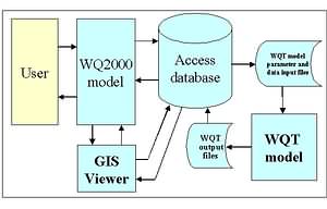
The WQ2000 model layout is shown in Figure 1.
Figure 2.1: WQ2000 Model structure
WQ2000 provides the interface between the user, a database containing a large amount of data for each quaternary catchment, the monthly-time step WQT hydro-salinity model and the DWAF's GIS Viewer.
This enables the user to run the WQT model for a selected quaternary catchment and view the results for four different conditions:
The user can elect to use default present day values, or to modify them via the user-friendly screen interface.
The GIS Viewer provides a means to present the results for a number of quaternaries.
HYDRO-SALINITY MODEL
The WQT hydro-salinity model represents the catchment system by means of user defined sub-system elements connected by flow routes. The following five discrete WQT sub-model elements are used in WQ2000:
The selected quaternary catchment is represented by two catchments, namely the quaternary catchment itself and the upstream catchment area.
MODEL CALIBRATION
The following factors prompted the selection of the Vaal River catchment as the study area:
DATA PREPARATION
A large amount of data had to be prepared for inclusion in the WQ2000 model. The default values reflected in the menu sheets are drawn from this data.
Three basic types of data are stored. These comprise:
The default values can be changed to reflect new or planned catchment developments. Permissible changes can be made to:
Any number of such changes can be made simultaneously for the selected quaternary catchment, and can be changed again in subsequent runs. Simulated quaternary catchment outflows can be stored as defined files. Such defined flows are used In subsequent runs for downstream quaternaries, obviating the need to re-simulate all the upstream quaternaries.
The main data sources used to populate the WQ2000 database include:
| WR90 | WRC Water Resources 90 reports and database |
| WSAM: | DWAF Water Situation Assessment model |
| VRSAU: | DWAF Vaal River System Analysis Update study. |
MODEL CAPABILITIES
Standard runs: WQ2000 allows simulation of time series of monthly flows and TDS concentrations for any selected quaternary catchment for natural or present day development conditions using the standard default values. The model then automatically generates a result summary that contains the following information for natural and present day conditions with and without the effect of inflows from upstream catchments:
User defined changes: One or more of the default parameter values may be changed. This powerful feature allows the user to play the "what if?" game. For example, the effect of a new dam, changed effluent discharge or effluent quality may be tested.
Mapping: WQ2000 allows the user to generate, display and print maps.
MODEL LIMITATIONS
WQ2000 is intended primarily to provide a rapid assessment of the expected salinity implications of a planned development, or to prepare an overview of the regional salinity status. This is a powerful and flexible tool. However, it does have limitations that need to be observed.
USER MANUAL
A user manual has been prepared. This is available in electronic form via the WQ2000 help menus.
FURTHER DEVELOPMENT
Two types of further development are proposed. These comprise extension of the WQ2000 model to include the rest of South Africa and improvements aimed at increasing the versatility the system.
Envisaged enhancements include:
CONCLUSIONS
The main conclusions are as follows:Attainment of project aims: The WQ2000 model has been successfully developed and applied to the Vaal River catchment. The study area includes both highly developed and undeveloped catchment areas. In many instances model calibrations were interpolated to cover large incremental catchments.
Model uses: WQ2000 provides a powerful means to rapidly assess catchment water quality using a sophisticated monthly time step hydro-salinity model, without the user needing any in-depth knowledge of the WQT model or its calibration. WQ2000 can be used to:
RECOMMENDATIONS
The following recommendations arise from the project:
Application of WQ2000: The WQ2000 model should be put to use by DWAF, consultants and Water Board practitioners as soon as possible. This will permit taking account of water quality at all levels of scheme development. The speed and ease of use of WQ2000 makes it feasible to carry out water quality assessments for even the smallest schemes and at the very earliest stages of project development.
Identification and solution of problems: It is anticipated that use of the model may reveal some shortcomings. It is strongly recommended that such problems are brought to the attention of the developers so that appropriate correction can be made. Provision should be made to issue a new distribution CD-ROM after one year's use and to set up a Web Site where new revisions can be posted.
Model improvements: Model enhancements that have already been identified should be implemented at an early stage. These include:
Extension to rest of South Africa: The WQ2000 model database should be extended to cover the remaining Water Management Areas (WMAs).
Recommended program: A phased approach is recommended: