STATUS GROUNDWATER EXPLORATION IN GEOLOGICALLY COMPLEX AND PROBLEMATIC TERRAIN - CASE Studies
Report No 966/2/02
April 2002
EXECUTIVE SUMMARY
1. Background
The Department of Water Affairs and Forestry has identified the provision of sustainable water and sanitation services to all as being one of its top priorities (DWAF, 1994). The challenge of providing developing rural areas in South Africa with sufficient potable water is substantial, especially where settlement is not densely concentrated and the ability to pay is low. The water requirements of these settlements can be met most cost-effectively from groundwater. The provision of these regions with sufficient potable water is complicated by the large backlog in water delivery, which results in pressure for rapid service delivery at the expense of time-consuming groundwater exploration methods.
Previous studies (King, 1997) have shown that some of the greatest water needs occur in regions underlain by fractured basement aquifers with complex hydrogeology and where the exploitation potential of groundwater has been thought to be low due to historically low drilling success rates or the high frequency of low yielding boreholes. Groundwater exploration success rates in these environments have been relatively low due to inappropriate exploration or interpretation methods resulting from an incomplete understanding of the geohydrology.
The current paradigm of groundwater exploration in South Africa, as well as in many other places in Africa, is based on a geophysical approach, where most boreholes are sited on anomalies identified from magnetic or electromagnetic traverses, often with little or no understanding of the structural geology of the target area. In many areas of complex hydrogeology this technique has proved to be unsuccessful for a variety of reasons. Specific causes that have been identified include:
As the demand for groundwater grows and the more obvious aquifers and target features become increasingly exploited, it can be expected that further development will have to consider alternative targets in such problematic and complex fractured geological environments. Significant savings in exploration and especially drilling costs can be realised if success rates could be improved. However, it is essential not to consider exploration in isolation from resource evaluation. If tl1ese complex terrain's are to be developed in a sustainable manner, the impol1ance of quantifying groundwater resources will be magnified due to the their low potential.
To improve the borehole success rate in these terrains, and to develop groundwater resources in a sustainable manner, a multi-disciplinary approach is needed. This approach must incorporate:
The Council for Geoscience undertook this project to re-evaluate the groundwater resources of some of these regions using a rigorous scientific approach, with tl1e objective of establishing a more successful exploration strategy.
A multidisciplinary approach was followed where structural geological mapping, tectonics, strain analysis, LANDSAT image interpretation and geophysical methods were combined to unravel the geodynamics of a region and to identify geological structures where groundwater could be located. These methods include:
Data collection for exploration is often costly and time consuming, hence it is important that any proposed techniques be fully analysed to determine their practical viability. Consequently, a financial analysis of the proposed methodology is presented, demonstrating that, although exploration costs of the adopted approach are higher, the ultimate establishment costs per successful water point and the costs of the water are dramatically reduced compared to conventional methods due to greatly improved success rates and significantly higher yields. These results suggest that it is cost effective to undertake groundwater exploration in a scientific manner, whether only successful points are required for hand pumps, or where high yields are required for reticulated motorised schemes.
From these results, a suggested method for exploration has been formulated to assist witl1 undertaking regional exploration programmes.
2. Research Objectives
The primary objective of this project is to investigate the development potential of groundwater in problematic or complex terrain where the demand for water for rural communities is expected to grow, and to develop guidelines for groundwater exploration and development in these environments. The supporting objectives are to:
The geological evaluation of target features and the guidelines for groundwater exploration will assist water practitioners with siting boreholes and interpreting geophysical data. Furthermore it will reduce the use of inappropriate geophysical methods and/or the. siting of boreholes based on an incorrect geophysical interpretation. This will reduce the frequency of incorrectly sited boreholes and increase the drilling success rate.
The evaluation of methods to estimate sustainable yield will assist consultants and implementing agents with planning pumping tests and. recommending pumping rates so that groundwater abstraction does not exceed sustainable yield of the aquifer.
3. Research Areas
Field data is provided from 4 study areas in South Africa. The four research areas were selected on the basis of the following criteria:
The area is densely populated rural region with underdeveloped infrastructure and services and has been identified as a critical water deficit area by DWAF.
Water scarcity is a serious problem and the area and relies mostly on springs, rivers, hand-dug wells and some boreholes. Groundwater would be a preferred water option in the area because of its generally availability even in drought situations and its relatively good quality.
The areas are underlain by fractured bedrock aquifers where success rates and borehole yields have been historically low, yet high yielding holes are present suggesting that suitable hydrogeological target features do exist.
The areas which have been studied include: the Natal Metamorphic Province of the KwaZulu- Natal south coast in the vicinity of Mapumulo; regions underlain by thick Dwyka Group rocks inland of the south coast in the vicinity of Harding; the greenstone belt of the Barberton Supergroup in the vicinity of Tjakastad, and the basement rocks and greenstones of the Limpopo Mobile Belt in the vicinity of Alldays.
4. Dwyka Group
The area of investigation is situated immediately north of the Transkei border, about 12 km - southeast of Harding in KwaZulu-Natal. Water demand in the study area is primarily for domestic purposes and partly for small-scale agricultural activity. Currently, water supply needs are met mostly from upland springs, rivers in the valley bottoms, and boreholes equipped with hand pumps. However, groundwater could play an important role, as it is a reliable water source, even in drought situations, and is generally of good quality compared to other water sources in the area. Water supply provision is complicated by the fact that settlement is concentrated on hill tops and extremely limited access exists to low lying areas, where a more assured water supply could be located. The extreme topography, however, would create static pumping heads of over 300 m; hence, groundwater exploration is predominantly restricted to the hill top regions.
The tillite has a very low permeability and forms a cover of up to 450 m thickness in the area, which prevents drilling through the formation into a more consistent aquifer. This fact is reflected in the very poor historical success rate in the area, with 84 % of the holes being dry.
These unfavourable hydraulic properties explain the relatively low yield of the aquifer. An average-blow yield of 0.14 l/s can be expected in wet boreholes; however, this is not sustainable on a continuous basis since fractures in the area are seldom interconnected. Hence long-term sustainability is limited for all but very low pumping rates. The investigations suggest that high yielding boreholes can only be found at sites where several interconnected fractures exist to enlarge the general low permeability of the formation. The massive nature of the rock and the brittle calcite filled fractures suggest that the formation may be a candidate for hydrofracturing to increase yields and fracture connectivity.
The research study showed that successful groundwater exploration for the area is possible, but should be limited to establish hand pump schemes. In addition, the water quality of the Dwyka tillites is suitable for domestic consumption. An evaluation of the structural geology and the hydrogeological conditions of the area together with a suitable geophysical method for the environment pushed the drilling success rate up from a historical 12 % to 50 %. The unfavourable hydraulic properties of the tillite however, limit tl1e yield of holes and median yields of successful holes could not be increased. Therefore, groundwater abstraction in the area will mostly be restricted to exploitation through hand pumps to support small communities. High yielding boreholes are seldom encountered and can only be found at major fault zones where interconnected fracture zones are present to distinctively enlarge the permeability of the subsurface. These are located at the margins of the Dwyka Group.
5. Natal Metamorphic Province
The Natal Metamorphic Province underlies 15% of all rural areas in KwaZulu-Natal and therefore underlies more of the rural areas than any other lithological province. It is also relatively densely settled. The research area is situated in the Mapumulo District of KwaZulu- Natal, about 30 km northwest of Stanger and 75 km north of Durban and extends over approximately 1300 km2. The area is bounded by steep sandstone cliffs to the east and west, while the Tugela thrust belt forms the northern boundary.
Water in the study area is used for domestic purposes and partly for small-scale agricultural activity. Currently, water supply needs are mostly met from rivers and springs, with boreholes equipped with hand pumps playing a secondary role. However, groundwater could play an important role, as it is a reliable water source, even in drought situations and is generally of good quality compared to other water sources in the area. Settlement varies from dispersed and isolated kraals to dense settlements in communities.
The rocks of the Natal Metamorphic Province are characterised by negligible primary porosity and groundwater movement is primarily within hard rock aquifers and controlled by zones of deep weathering, faulting, fracturing and jointing. Accordingly, water strikes or seepage encountered in the exploration boreholes drilled during the investigations are either associated with the contact between weathered and solid bedrock, or deep-seated fracture zones of low pel1neability but high confining pressure. There is no evidence of any additional aquifers at contacts between different lithologies, suggesting that tectonic contacts are more relevant than lithological contacts. Lithological variations are more significant in terms of water quality, with poorer water quality having been recorded in schists and granites (King, 1997).
The area exhibits a poor historical success rate with about 46% of the holes being dry. Borehole yields are generally low with only 23% giving a yield greater than 1 l/s, however in this study greater than 75% of boreholes yielded more than 1 l/s. These reported borehole yields are mainly derived from blow tests and seldom from a long duration test. Therefore the percentage of boreholes with a sustainable yield exceeding 1 l/s is likely to be much lower. Dry boreholes as well as high yielding holes have been drilled into all lithologies and are not restricted to any specific rock type; poor and high yielding holes occur within the same lithology and give evidence that structures of tectonic origin are a major factor influencing groundwater occurrence.
During the Critical Intervention Programme, where only geophysical siting was used, 37% of 27 boreholes drilled in the study area were dry and only 2 had blow yields exceeding 1 l/s. The median yield of successful holes was 0.1 l/s. This study achieved an 89% success rate, with 7 of 9 boreholes exceeding 1 l/s and a median yield of between 1.8-3.3 l/s. This suggests that the aquifer can be reconsidered in terms of reticulated water supply if a scientifically appropriate exploration strategy is adhered to.
The research showed that successful groundwater exploration for the area is possible. An evaluation of the structural geology and the hydrogeological conditions of the area together with a suitable geophysical metll0d for the environment pushed the drilling success rate up from a historical 54% (NGDB) and 63% (Critical Intervention Program) to 89%. Beside the improved success rates, the research did result in significantly improved yields. Whereas the median yield for the NGDB and CIP records is 0.1 l/s, a median yield of 1.8 l/s was achieved with the applied exploration method, which accordingly lowers water production costs considerably. The average yield of all boreholes was pushed up from a historical 0.96 l/s to 2.55 1/s.
6. Limpopo Mobile Belt
The research area is situated near the northern border of the Northern Province in the Limpopo River catchment and is underlain by rocks of the Limpopo Mobile Belt (LMB). This geological province is an E- W elongated low lying belt straddling eastern Botswana, southern Zimbabwe and the northern part of the Northern Province in South Africa. Two study areas were selected within the belt, one situated in the northern Bochum District west and southwest of Alldays (study area I), and the other (study area II) is located in Messina District east of Messina (Figure 6-1). Study area I is characteristic of the western part of the LMB, where a quaternary sand cover overlies the metamorphic basement rocks. Rock outcrops are few and the topography is level. Study area II represents the situation in the eastern part of the LMB, where the basement rocks are exposed at surface, with rare occurrences of quaternary cover.
The area exhibits a poor historical success rate with <40%of boreholes yielding water yielding more than 0.1 l/s. Borehole yields fall mainly in the category between 0.01 and 1 l/s (69% study area I and 45% study area II), with the median yield of successful boreholes being only 0.39 l/s. Only 13% of boreholes yield more than 2 l/s. Dry boreholes as well as high yielding boreholes have been drilled in all litll010gies and are not restricted to any specific rock type.
The aquifers of the Limpopo Mobile Belt are predominantly structurally controlled and significant water movement is restricted to major fracture and fault zones, primarily related to recent (Post Karoo) geodynamics. These structures can be extremely high yielding and can generate blow yields in excess of 20 l/s. In many instances the distance to streams and rivers is indicative of a fault zone, since many rivers tend to follow structures when they deviate or dogleg from the northerly surface topographic gradient. The highest yielding boreholes are drilled into ENE striking features, the orientation considered as extensional in nature.
However, the scale of the feature shows a strong influence on the yield of the boreholes with regional scale fault having a far better groundwater potential than local scale structures.
The results suggest that the Limpopo Mobile Belt is a poor aquifer due to marginal to poor water quality (class II-III) related to nitrate levels, low recharge and the extreme heterogeneity in targets. Low success rates exist concurrently with very high yielding features; however, these are restricted to mainly regional scale fault zones. Smaller fault zones and alluvial cover along the streams provide a more limited aquifer. Consequently, water abstraction will have to be reliant on regional abstraction systems from identified structures and reticulation to the point of need. Fortunately, the flat topography does not hinder reticulation.
7. Barberton Greenstone Belt
The study showed that an evaluation of the structural geology and the hydrogeological conditions of the area together with a suitable geophysical method for the environment pushed the drilling success rate up from a historical 50% (NGDB) to 89%. Beside the improved success rates, the proposed methodology resulted in significantly improved yields.
A substantial cut in costs in terms of water production expressed as Rills was achieved during this exploration programme. Historic success rates have resulted in an expenditure of approximately R24200 for the establishment of each successful borehole. In comparison, with an exploration budget of about R55000 for the proposed methodology, success rates of 89% can be expected and establishment costs would come down to about R19875 per successful borehole.
Median yields were increased from 0.4 l/s to up to 1.0 l/s, which brings down the costs of water production from 60500 R/l/s in case of random drilling to 18370 R/l/s in this project. The high median yield achieved during this project suggests that water supply systems in the area could involve reticulated systems.
Groundwater is an important resource in the study area, providing a clean, reliable, low cost water source. The geology of the area consists of impermeable granites and meta-basalts metamorphosed at a low-grade amphibolite schist to green schist facies, Fractures in the granites have been intruded by extensive quartz veining, which renders them relatively impermeable and makes them poor targets for groundwater exploration. The meta-basalts are the best targets for groundwater exploration, especially where fracture zones associated with faults and dykes are present.
Dip-slip and strike-slip faults were water bearing and are associated with the formation of deep open cavities that enhance the permeability of the greenstones. The geodynamic and strain analyses suggest that structures having a NNE -SSW strike direction are more likely to be under extension and therefore open, hence they are the primary hydrogeological targets. The E- W striking lineaments are more likely to be strike-slip faults and are also the hydrogeological targets if the target is not a shear zone where gouge material has reduced permeability. The N-S lineaments are expected to have high yielding holes as well, but only if the targeted lineament is a fault, however, this was not proven by the drilling results.
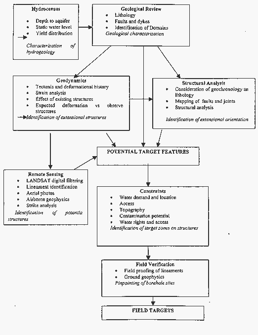
8. Guidelines for Exploration in Complex Terrain
Potential hydrogeological targets are often selected based on a hydrocensus and/or a geological review of existing geological maps. Boreholes are subsequently sited using ground-based geophysics, with the EM-34 and magnetometer being the most widely used methods. This approach has been widely used in the study areas investigated, and has been shown to be relatively unsuccessful and uneconomical when compared to the results that could be achieved by a more integrated and geologically focussed approach. However, using data from the Critical Intervention Programme in KwaZulu-Natal, where the above mentioned geophysical approach was adopted, the geophysical approach has been shown to be more economical than historical success rates, however, median yields were NOT increased. The major disadvantage of this method is that the nature of the hydrogeological targets is rarely understood, neither are the structural and geological stress conditions that control the orientation of structures, which in turn control the distribution of groundwater yield. Consequently, the method is commonly no more than 'anomaly hunting', with geophysical anomalies being attributed to potential weathering profiles, intrusive contacts, or potentially water bearing fracture zones that are assumed to be hydrogeological targets. Often little is known about variations in rock mineralogy, the presence of clay gouge in shears, or the existence of complex folding of the rock fabric, all of which could result in geophysical anomalies. These conditions result in geophysical anomalies over features that are not hydrogeologically significant or even water bearing, In addition, little is known about the regional extensiveness of potential targets or current structural stresses that determine whether the feature is hydrogeologically significant.
The addition of remote sensing to the exploration toolbox allows the regional extensiveness of targets to be identified, LANDSAT TM images or aerial photos assist with identifying potential geological lineaments tl1at are regionally significant so that ground based geophysics can be more intelligently directed towards the location of specific targets. However, such lineaments are not always structurally significant, and the geological stresses responsible for tl1e features are not understood, hence their ultimate water bearing potential is unknown.
A study of the tectonic history and the geodynamics of a region offers the advantage of providing a framework for identifying targets that are hydrogeologically significant based on tl1e understanding of current stress conditions. Consequently, structurally significant lineaments can be identified and geophysical exploration restricted to targets considered to be of greatest potential.
Hydrocensus
Objective
The objective of a hydrocensus is to hydrogeologically characterise a region in terms of tl1e physical and economic feasibility of meeting water demands through groundwater by quantifying:
These investigations should attempt to determine the number of boreholes that will be required to meet water demands, the role of geological structures on yield, the depth to which boreholes should be drilled, and the suitability of water quality for the desired usage.
The location of high yielding boreholes may also assist in identifying targets that are potentially high yielding.
A hydrocensus should ideally also consider geological processes or mineralogies that may negatively impact on groundwater quality in the long term. Critical factors, such as the presence of volcanic massive sulphide deposits, hydrothermal alteration, carbonaceous shales, carbonatites etc., may be indicators of the presence of heavy metals, light metals and non- metals, heavy non-metals, halogens, alkaline earths, rare earths and noble metals that may pose a significant long term health hazard. These elements may be present in the rock but not observed in water samples from recently drilled boreholes; their mobility may be controlled by oxidation-reduction conditions that alter with time. A typical example is arsenic, which is prevalent in South Africa as arsenopyrites, but whose mobility is controlled by oxidation state. Consequently, its presence would only begin to appear in water samples after variations in drawdown due to pumping have introduced oxygen into the formation, resulting in oxidation and weathering.
Methodology
The hydrocensus is conducted by collecting data from the National Groundwater Data Base and previous hydrogeological investigations and subsequently overlaying the data onto existing geological maps using a GIS. The specific processes are:
Tectonics and Geodynamics
Objective
Geodynamic investigations require that the tectonic history of the target be unravelled so that mapped, identified or presumed structures and lineaments can be explained in terms of historic and present day geological strain. Depending on the age of the rocks and the structural complexity, this process may involve extensive literature review on the crustal evolution of the region. Since these processes are of a large scale, investigations often are much broader than the study area. For example, an understanding of the geodynamics of the Natal Metamorphic Province requires a comprehension of Archean craton movement and offshore transform faulting along the Aghulas Transform Fault during the break-up of Gondwanaland. The Limpopo Mobile Belt requires investigation into plate tectonics and craton collision during Archean times, and subsequent shearing during mobile belt emplacement.
Emphasis is given to tectonic events that resulted in brittle deformation, however, in many cases brittle deformation occurs along zones of existing weakness resulting from earlier ductile deformation, such as ENE faulting in the Natal Metamorphic Province along earlier ductile ENE shears.
Geodynamic investigations aim to develop a conceptual model of pre- post- and syntectonic geological evolution that describes historical extension, compression and shear orientations in geological time. The objective is to define a chronologically expected pattern to explain observed faulting by strain analysis using a strain ellipse. The potential rejuvenation of such structures by subsequent tectonic events can then be identified and the present strain on existing structures can be identified. Existing structures considered to be under extension present hydrogeological targets.
Strain analysis conducted during geodynamic investigations also permits an understanding or classification of observed lineaments and joint patterns in terms of their origin and present strain conditions, hence allowing the identification of preferred structures.
Methodology
The process involves investigations into:
Structural Analysis
Objective
A structural analysis attempts to identify strain conditions in rocks by identifying compressional and tensional orientations by mapping the strike and dip of joints and plotting the data on stereonets. The objective is to identify the orientation that is extensional, so that geological structures aligned perpendicular to extension can be identified. These targets are then assumed to be open and are targeted as preferential targets.
The risk of using this methodology is that in many cases rocks have been exposed to several tectonic events, perhaps with different stress orientations, hence jointing from several generations may be superimposed in joint patterns. Consequently, joints may be aligned in many orientations and the resulting structural analysis would be meaningless unless conducted on subsets related to a specific event. Identifying joint patterns from specific events requires a geodynamic analysis to identify stresses originating at various periods in time. A specific example can be observed in the Limpopo Mobile Belt, where joints are the result of late Archean shear, with post Karoo extension superimposed. For this reason, it is often necessary to conduct joint mapping in the most recent lithological formation present, even if outside the study area, to identify stresses originating from the most recent tectonic event. This process allows coarse dating of joint sets.
Methodology
The investigations conducted include:
Remote Sensing
Objectives
The objective of using remote sensing methods is to identify structures that may be of hydrogeological significance and that are not noticeable in the field, or that have not already been mapped. These can be identified by satellite images using variations in surface reflectance, by aerial photos using variations in tone and contrast, or by airborne geophysics, which is based on variations in rock physical properties. Often digital filters are used to enhance features considered to be of interest, such as vegetation, structure, soil moisture, clay content, magnetic field etc.
Identified lineaments are presumed to have a hydrogeological significance, and are presumed to be related to lithological variations, faults, variations in saturation, topographical depressions are linear vegetation trends. However, field proofing is necessary to verify the nature of the identified lineament.
Unless a geodynamic analysis has been undertaken, it is usually not possible to identify the stress regime of a lineament or its structural significance. To some extent this is overcome by an analysis of lineament orientation and length so that the predominant regional scale features can be identified.
The usefulness of remote sensing is hindered where:
Methodology
Remote sensing investigations ideally require the following steps:
Field Verification Investigations
Objective
Field proofing investigations are required to idel1tify the nature of target lineaments to determine their nature and origin, and to pinpoint the lineaments in the field using observation or geophysics with due consideration being given to constraints on siting. The objective is to identify drilling sites on structural features identified as being of hydrogeological significance at locations where drilling and water abstraction are physically, economically, socially and legally acceptable.
A field survey is also required to evaluate the effect of constraints on target site selection.
These constraints may include:
These constraints impact on the point at which specific linear targets may be targeted and ultimately determine where the boreholes can be sited.
Methodology
Field investigations include:
9. Conclusions and Recommendations
The results obtained in the 4 selected study areas show that the methodology employed results in increased borehole success rates compared to previous drilling, as recorded in the National Groundwater Database and the Critical Intervention Programme, which utilised a geophysical approach:
Borehole Success Indicators
| Geology | Success Rate | Median Yield | ||||
| 1 | 2 | 3 | 1 | 2 | 3 | |
| Dwyka Tillite | 12% | 27% | 50% | 0.16 l/S | 0.1 l/S | 0.1 l/S |
| NMP | 50% | 63% | 89% | 0.1 l/S | 0.1 l/s | 1.8 l/s |
| LMB | 40% | 38% | 66% | 0.39 l/s | 0.1 l/s | 3.9 l/s |
| BGB | 50% | 89% | 0.4 l/s | 1.2 l/s | ||
Financial Indicators
| Geology | R/successful borehole | R/l/s |
||||
| 1 | 2 | 3 | 1 | 2 | 3 | |
| Dwyka | 99473 | 52100 | 28600 | 621706 | 521000 | 286000 |
| NMP | 22990 | 20710 | 18370 | 229900 | 207100 | 10206 |
| LMB | 30250 | 34855 | 24390 | 77564 | 348550 | 6254 |
| BGB | 24200 | 19875 | 60500 | 18370 | ||
The project indicates that groundwater exploration is significantly more cost effective when structural controls on groundwater occurrence are considered so that only potentially significant targets are considered for field investigation. However, groundwater exploration exhibits a significant economy of scale and unit costs per borehole decrease with the number of boreholes drilled. In the Dwyka Tillites exploration costs as a proportion of total borehole establishment costs were shown to drop from 27% for 3 boreholes to 14% for 20 boreholes to 12% for 50 boreholes. Consequently, such an approach is warranted only when the exploration costs can be distributed over several boreholes. Based on financial analyses for establishing 10 boreholes, the proposed methodology proved to be cost-effective in all the geological provinces investigated. Cost-effectiveness would subsequently increase with the number of boreholes required in each study area.
Consequently, cost effective groundwater exploration should:
The above-mentioned conclusions suggest that there is a significant need for a fundamental paradigm shift in groundwater exploration in South Africa. All of the above lessons can be considered as being opposed or contradictory to the current practice of groundwater exploration for rural water supply.
10. Recommendations for Future Research
The major shortcoming encountered during the project was that the current situation in South Africa has resulted in a fundamental split between geological mapping and groundwater exploration. Geological mapping has been lithologically and petrologically oriented, with little attention being paid to structures other than mapping the location of major faults. Little or no attention has been paid to joint mapping to permit a structural analysis. In addition, tectonic evolution, where it has been considered, has often ignored more recent post- deposition deformation. For example, resulting strain and stresses on Archean rocks resulting from the break-up of Gondwanaland is rarely described and the geological community has concentrated on Archean tectonics and unravelling the complexities related to the ages of metamorphic episodes. As a result, a hydrogeologist considering a structural analysis of target features must go through a mapping exercise. This project has shown that structural analysis usually requires 2 days to complete 4 1:50 000 sheets, however, a tectonic interpretation may require extensive literature review and the application of strain analyses to an observed fault set since the required information on recent tectonics is rarely available. This shortcoming requires that the scope of geological mapping be broadened if the results are to be of greater value to the hydrogeological community. A programme of structural mapping is urgently required if groundwater targets are to be regionally identified.
In contrast, the hydrogeological community has paid scant if any attention to the importance of geodynamics and structural analysis in groundwater exploration. Consequently, exploration has not been focussed and has been relegated to an exercise in anomaly hunting that adds little to the identification of future targets. A structural understanding of the aquifer is rarely built up and mistakes are commonly repeated. This shortcoming may reflect a lack of training in structural geology in South Africa, which is fundamental to groundwater exploration in fractured aquifers. This lack of awareness has resulted in minimal attention being given to structural models in hydrogeological investigations.
Urgent attention also needs to be given to cost-benefit analyses of past and current groundwater exploration strategies, as it is only by using the language of economics that the voice of hydrogeologists calling for a revision in exploration strategy will be heard.
Figure 1. Flow Chart of the Groundwater Exploration process